Abroad Thoughts from Home
Of Parallels and
Meridians: Implications of Barents
Sea Dispute Resolution for the Beaufort Sea Clive Schofield and
Ian Townsend-Gault On 7 July 2011, the
Norwegian Foreign Minister, Jonas Gahr Støre and his Russian counterpart,
Sergei Lavarov, exchanged instruments of ratification on the Treaty
on Maritime Delimitation and Cooperation in the Barents Sea and Arctic
Ocean.1 The agreement, signed on 27 April 2010, was ratified
by the Norwegian parliament on 8 February 2011 and by Russia's State
Duma on 25 March 2011. This treaty on the delimitation of a maritime
boundary resolves Norway and Russia's longstanding dispute over the
Barents Sea. What is the significance
of the Norway-Russia deal and does it have any parallels and implications
for the settlement of Canada and the United States' similarly
substantial and enduring dispute in the Beaufort Sea? An Arena for Cooperation
rather than Conflict? Perhaps the most salient
and striking aspect of the Barents Sea agreement is that it marks the
peaceful settlement of a long-running and previously apparently intractable
boundary dispute among two neighbouring Arctic States. This runs distinctly
counter to much of the contemporary narrative on the Arctic region as
an arena for increasing resource-driven jurisdictional and geopolitical
rivalry and thus potential conflict. Suggestions that the
Arctic is the focus of a multi-player "land grab"2 and
resource access-related "scramble"3 or "race"4
have been widespread since reports of the substantial melting of Arctic
summer sea ice cover emerged and particularly in the wake of Russia's
planting of a flag on the sea floor beneath the North Pole in 2007.
Such imagery of a contested region has been sustained over time and
are by no means merely confined to media analysis. For example, in October
2010 a senior NATO Commander, US Navy Admiral James G Stavridis, supreme
allied commander for Europe, warned that a warming Arctic and a race
for resources could lead to a new "cold war" in the Arctic.5
Stavridis observed that: "For now, the disputes in the north have
been dealt with peacefully, but climate change could alter the equilibrium
over the coming years in the race of temptation for exploitation of
more readily accessible natural resources," and cited the melting
of the Arctic ice cap as "a global concern" because of its potential
to "alter the geopolitical balance in the Arctic heretofore frozen
in time."6 Consistent with the
apparently commonly held view of the Arctic as an area ripe for geopolitical
and resource driven competition and potentially conflict, unleashed
by the melting of summer sea ice, is the perception of the maritime
claims of the Arctic coastal States are symptomatic of this trend. In
this context claims to maritime jurisdiction on the part of the Arctic
coastal States, including recent and forecast submissions related to
extended continental shelf rights, and the actual or potential overlaps
between them, have often been characterised as potential source of dispute
and triggers for conflict. Alternatively it can
be observed that the claims of the Arctic coastal States are, in fact,
consistent with international norms and particularly the United Nations
Convention on the Law of the Sea (LOSC).7 Four of the five
Arctic littoral States are parties to LOSC and the sole non-party, the
United States, acts in a manner consistent with the Convention with
respect to its maritime claims.8 Indeed, the maritime jurisdictional
claims of all the Arctic States are in keeping with the provisions of
LOSC. This also applies to the submissions that the Arctic States have
either made or are preparing in respect of areas of extended continental
shelf located seawards of the 200 nautical mile limit from baselines.
Such submissions are made to the relevant United Nations scientific
body - the Commission on the Limits of the Continental Shelf (CLCS).
That Arctic States such as Russia (2001) and Norway (2006) have made
submissions to the CLCS and that there are strong indications that other
Arctic States will follow suit in due course (Canada's deadline falling
in 2013 and Denmark's in 2014), represents further evidence that the
Arctic States are acting in line with international law. Norway and Russia's
resolution of their longstanding maritime boundary dispute offers compelling
evidence that the Arctic States are capable of resolving their differences
in a peaceful and cooperative manner. Indeed, on signing the agreement,
Russian President Medvedev termed the agreement a way for the two States
to "turn a new page" in relations and "a key step forward"
whilst Norwegian Prime Minister Jens Stoltenberg referred to the treaty
as a "historic milestone" and "new era of cooperation."9
In a joint statement both leaders hailed the agreement as a symbol of
the Arctic as peaceful region where disputes resolved in accordance
with international law.10 Parallels between
the Barents and Beaufort Seas Intriguingly, there
are strong parallels between the Barents Sea and Beaufort Sea cases.
Both disputes essentially arise (or arose in respect of the Barents
Sea) from one parties desire for a maritime boundary delimitation based
on an equidistance line and the other parties' insistence on
a boundary line consistent with a sector, that is due north-south, line.
Thus, Norway and Russia's overlapping maritime claims in the Barents
Sea were essentially caused by Norway's preference for a median line
and Russia's insistence on a sector line solution. This fundamental
difference in maritime delimitation methodology led to a broad area
of overlapping claims encompassing 175,000km2 (see Figure
1).
Analogous to the Barents
Sea scenario, the Canada-US dispute in the Beaufort Sea centres on differing
approaches to maritime delimitation in the area. The U.S. insists on
an equidistance line as a basis for delimitation, but Canada might argue
that the maritime boundary should be a seaward extension of the 141º
W meridian, which provides the boundary between Alaska and the Yukon
Territory. These positions represent the conventional approach (United
States) and the sector-based approach (Canada), the two main approaches
to maritime boundary delimitation.11 One point worth observing
is that while the sector-based approach is clearly more favourable to
Canada in the area immediately offshore of the coast, this is not the
case further offshore. This is essentially because of the influence
of Canadian Arctic islands on the course of a theoretical equidistance
line (see Figure 2). Overall, therefore, Canada's sector-based approach
(if agreed to by its neighbouring States) would deliver considerably
less maritime space to Canada than the application of strict equidistance
lines. Whether these additional areas further offshore are as potentially
important from a resource access perspective is, however, a different
question. The boundary line delimited
through the Treaty on Maritime Delimitation and Cooperation in the Barents
Sea and Arctic Ocean serves to divide the area of overlap through the
delimitation of a single maritime boundary for exclusive economic zone
(EEZ) and continental shelf rights out to the 200 nautical mile limit
from the mainland coasts of the parties, a continental shelf boundary
with respect to the so-called 'Barents Sea Loophole' beyond
200 nautical miles from either States baselines, and a delimitation
through the northern Barents Sea for the continental shelf and also
the Norwegian fisheries protection zone defined on behalf of Svalbard
and the Russian EEZ (generated from the islands of Franz Josef Land
and Novaya Zemlya).12 Perhaps unsurprisingly the agreed boundary
line represents a compromise between the parties contending positions
- arguably an obvious yet nonetheless critical lesson for Beaufort
Sea dispute resolution. Is the present deadlock
in the Beaufort Sea likely to change anytime soon? Perhaps. Certainly
there are indications that the issue is acquiring greater impetus and
is of rising importance on domestic and bilateral political agendas.
Indeed, report issued by the Canadian government in August 2010 reportedly
indicated that in a "historic shift" Canada would make the
resolution of Arctic boundary disputes top foreign-policy priority in
the Far North.13 Further, Prime Minister Harper of Canada
and President Obama of the United States have gone on record to state
their intention to resolve their boundary disputes with alacrity. That
said, substantial challenges lie ahead in both the Barents and Beaufort
Seas. In This Issue The boundary is
only the beginning... That the maritime boundary
issue has been settled in the Barents Sea is to be welcomed with open
arms. Arguably, however, the hard work is only just starting. Whilst
the Norwegian sector of the Barents Sea has been subject to substantial
management efforts through the Integrated Management Plan for Barents
Sea and Lofoten Islands.14 This plan can be classified as
a success in that it has promoted scientific monitoring and research
assisted in the management of oil and gas activity and therefore helped
to minimise conflict between sectors. However, it can be observed that
the plan and its related activities are still at an early stage of development,
indicating that there is much work left to do. The principal challenge
now will be to extend the ecosystem approach central to the management
of the Norwegian sector of the Barents Sea across the boundary to encompass
the Russian Barents also. While the plan as currently conceived covers
an enormous area (1.4 million km2) from the Lofoten archipelago
to the north of Svalbard and to east to the boundary with Russia,15
and also applies from one nautical mile off the coast (the inshore is
managed according to the EU Water Framework Directive) to the limits
of the Norwegian EEZ, it does not cover the Russian portion of the Barents
Sea across the now agreed and ratified Norwegian-Russian border. That
said, significant bilateral cooperation does exist in the realm of fisheries
which remains the dominant maritime industry in the Barents Sea. In
this context, the Norwegian-Russian Fisheries Commission, under advice
from the International Council for Exploration of the Sea (ICES), plays
an influential role and is indicative of strong existing and ongoing
bilateral cooperation between the Barents Sea littoral States. Nonetheless, in order
to achieve integrated, holistic management of the Barents substantial
and sustained political will to drive such transboundary cooperation
will inevitably be vital. This is particularly important because increasing
maritime activities in the Arctic are disproportionately focussed towards
the Barents Sea. The Barents Sea region is therefore likely to see the
most intensive developments witnessed Arctic-wide and this, in turn,
will create additional pressures on the cooperative management regime
there. For example, it was
notable that the Norwegian and Russian Foreign Ministers, when announcing
the exchange of instruments of ratification for the treaty on maritime
delimitation in the Barents Sea and Arctic Ocean, framed the agreement
in resource access terms. For example, the Norwegian Foreign Minister,
whilst suggesting that the treaty "made it clear that there is no
ongoing race for resources in the Arctic", stated that close bilateral
cooperation on fisheries in the Barents Sea would continue and that
the agreement also "creates new opportunities for petroleum activities
and cooperation" in the Barents Sea.16 Such pronouncements
immediately drew criticism from concerned NGOs such as Greenpeace. Reconciling
increasing economic activity with the fragile environment of the Barents
Sea in a transboundary context therefore raises multiple inter-related
challenges. Constitutional conundrums
in the Beaufort Sea For Canada, pursuing
boundary negotiations in the Beaufort Sea will force the country to
consider the status of the "sector theory". As noted above, this
holds, in its simplest form, that Canada should claim the marine area
bounded in the west by the 141º W meridian up to the North Pole, with
the eastern arm being meeting the median line maritime boundary with
Greenland. This has never been official Canadian government policy,
yet nearly every map of Canada shows the sector, often designated as
an "international boundary". The problem is that
the U.S. government has no intention of accepting the 141º W meridian
as its maritime boundary with Canada. Rather, it insists that the common
international practice be followed, and the boundary should be an equidistance
line (see Figure 2). In the circumstances, it may be difficult for Canada
to counter this position especially since, as has been said, it has
never formally claimed the sector. It would be difficult to justify
a meridian line on the basis of international law. Reference to the
Barents Sea parallel for instance indicates that Russia abandoned their
own sector-line claims.
But there is a complicating
factor here. Ottawa has entered into a land claim agreement with the
Inuit, part of which includes a marine area bounded by the 141º W meridian,
and which extends more than 200 nautical miles from Canadian land. Such
agreements enjoy constitutional protection, and it would be very difficult
in domestic terms for Canada to agree to a boundary which resulted in
any part of this area coming within U.S. jurisdiction. For its part,
Washington can say - perfectly reasonably - that Ottawa agreed to
a land claim with respect to marine areas which were not Canada's
to dispose of. Canada's domestic constitutional concerns have no bearing
at all on international rights or entitlements. The Barents Sea experience,
as well as wider past practice in maritime delimitation, suggests that
Canada is exceedingly unlikely to persuade the United States to agree
to a boundary line along the 141º W meridian. Instead a compromise
line somewhere between either sides' claim line is considerably more
plausible. Further problems will
ensue if Canada attempts to enforce its jurisdiction - on behalf
of the Inuit - in that part of the claim area beyond 200 nautical
miles, that is, beyond the limits of Canada's rights at international
law, and indeed what it claims in domestic law. Any attempt to interdict
foreign vessels fishing there would be unlawful. The fact that the Inuit
may claim this to have been their traditional waters will have no impact
on the international legal position. How did Canada get
itself into this situation? The answer can only be that the federal
negotiators did not fully realise the consequences of what they were
doing, and advice was not sought from appropriate quarters. Or if such
advice was forthcoming, it was ignored. In either case, the conundrum
has the potential for grave embarrassments, internationally and domestically.
But since Prime Minister Harper and President Obama seem set on effecting
the Beaufort boundary, these issues will have to be faced sooner rather
than later. How, then, can Canada
get out of this situation? It is suggested that a key component of such
a solution would be to bring the Inuit into the boundary negotiations
on the understanding that the maritime part of the land claim area might
have to be re-negotiated. In essence the Canada's constitutional dilemma
in the Beaufort Sea can be circumvented if the spatial limits of the
land claim area can be amended to fit any agreed line with the United
States. It necessarily follows that involving the Inuit in the negotiations
with the U.S. is critical to achieving this outcome and clearing the
way for further peaceful boundary dispute resolution between Arctic
States.

with Ian Townsend-Gault
Director of the Centre for Asian Legal Studies
Faculty of Law, University of British Columbia
Vancouver, Canada
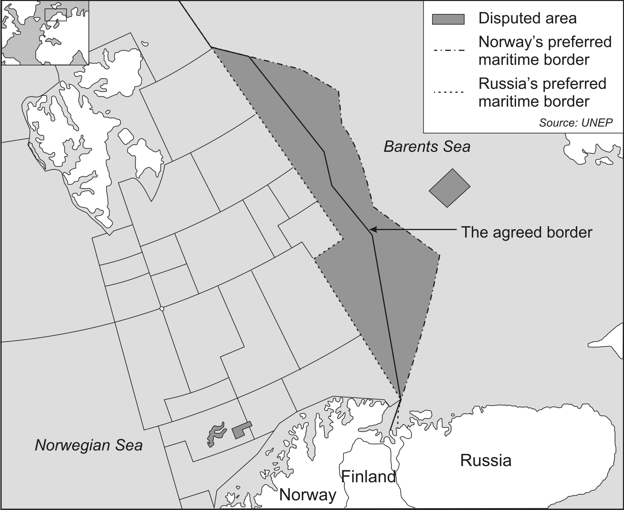
Figure 1. Barents Sea
Looking At Things
Differently Changes What You See
Steve Wexler
UBC law professor Steve Wexler discusses a breakthrough
in his thinking about the individual's perspective on law and its coherency.
Unanimism: Between Sociology and Psychology
Sirus Kashefi
Dr. Kashefi takes a critical look at Unanimism,
whereby "members of a group do or think
something simultaneously". He analyzes the
concept of Unanimism on the basis of collective
behaviour's psychological consciousness and
unconsciousness, as well as its sociologically
observed rationality or irrationality. In this era
of protest and unrest, these are timely and
valuable considerations.
The Japanese Art of
Soji Contrasted With Western Unwillingness
Martin Novotny
Actor, Instructor, and Martial Arts Enthusiast Martin Novotny discusses the benefits
of practicing the Japanese art of Soji which carries with it multivariate benefits for both person and place.
Literary Voices
Literary Contributions from Bateman-Ezra, Michael O'Connor, Martin Burke, and Clinton Van Inman
Literary selections from an international cast of writers.
IZ's Commitment to Somalia
Aweis Issa
Somali citizen Aweis Issa writes about the situation on the ground in Somalia.
Tweet
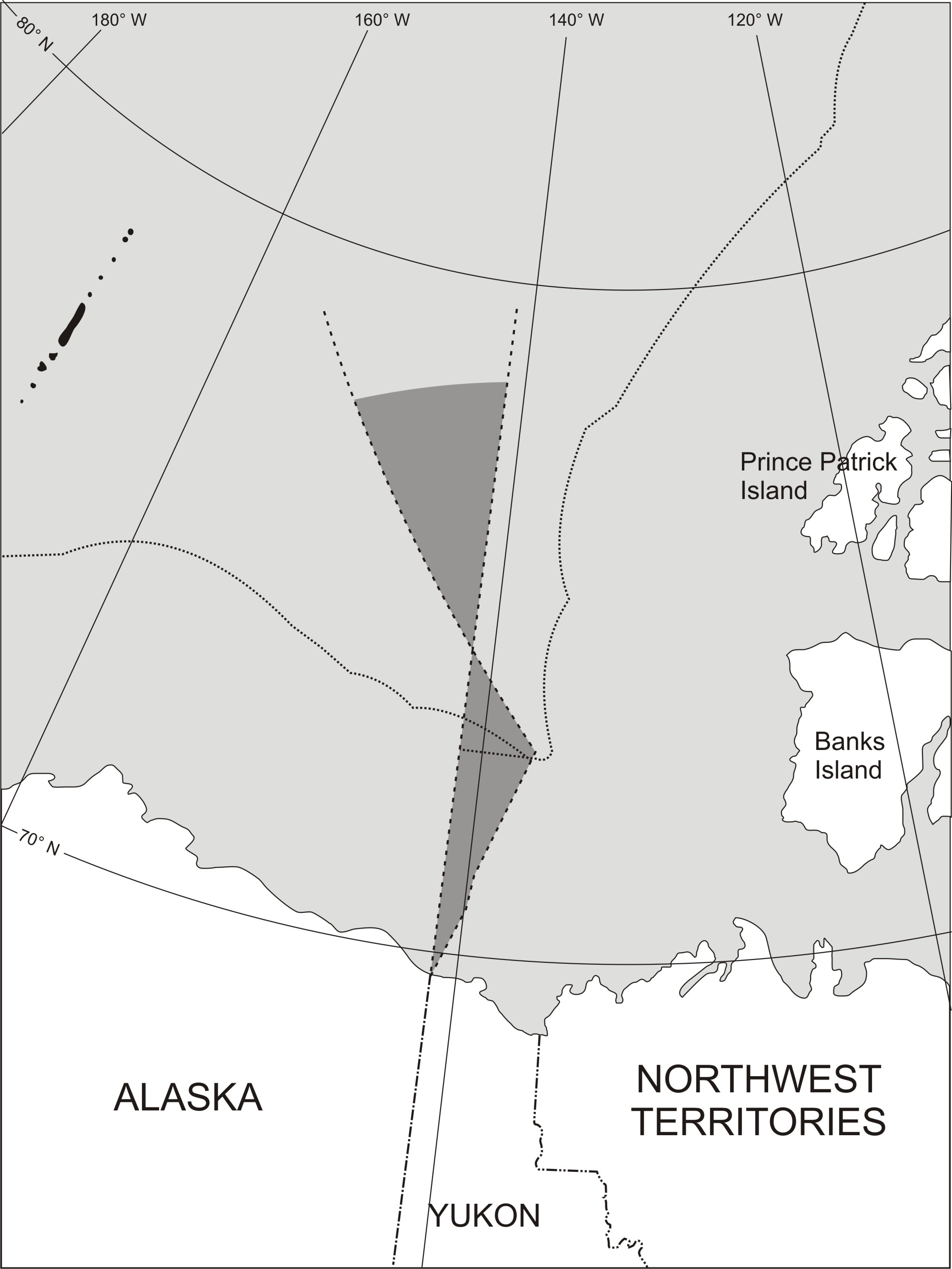
Figure 2. Beaufort Sea