F o r I n f o r m a t i v e D i a l o g u e o n W o r l d E v e n t s
About ·
Submissions ·
Archived Issues ·
Home
Volume 5
July 2009
Number 2
|
Abroad Thoughts from Home
Extending the
"Baguette" Introduction Wednesday 13 May 2009
was something of a red-letter day in the law of the sea and international
law more generally. That was the deadline for many coastal States to
make submissions regarding areas of continental shelf located seaward
of 200 nautical miles from their baselines along their coasts. Such
areas of continental shelf located beyond the 200 nautical mile limit
are generally termed the 'outer' or 'extended' continental shelf.
According to some of the more excitable (read: far-fetched and misleading)
media coverage, the world has just witnessed the largest "land grab"
in history. But how can one have a land grab without the land? Much as students treat
deadlines for essays (or Professors deal with due dates for academic
articles), many States left it late. Amid the flurry of submissions
related to outer continental shelf areas that the May deadline stimulated
was a submission on the part of France which is intriguing in its own
right because of its novel character, but is also of particular interest
to Canada since Canada's sovereign rights offshore appear to be challenged. It is fair to observe
that international lawyers and other students of the law of the sea
drawn from different disciplines, such as geography, usually welcome
innovative approaches to this complex subject. It reminds them that
there is sometimes something new under the sun after all. Clearly, on
occasion, States have the capacity to surprise us and unveil fresh and
challenging new approaches and interpretations to the various aspects
of the international law of the sea. France has sprung just such a surprise
in respect of its assertions to the United Nations, albeit in preliminary
form, that part of the continental shelf of the northwest Atlantic lying
beyond 200 nautical miles from the coast represents part of the French
continental shelf by virtue of the presence of a group of islands, referred
to collectively as St. Pierre and Miquelon after the group's two main
islands, under French sovereignty and located to the south of the island
of Newfoundland.1 International law certainly
permits coastal States to exercise resource jurisdiction over submarine
areas beyond 200 nautical miles where the area in question can be shown
to be part of the continental shelf or margin of the coastal State:
it's natural prolongation, in other words. The nub of the problem
here is that while St. Pierre and Miquelon do generate claims to maritime
jurisdiction on behalf of France, notably a 12 nautical mile breadth
territorial sea and an exclusive economic zone (EEZ) out to 200 nautical
miles, these maritime zones are entirely surrounded or enclaved within
the analogous Canadian zones of maritime jurisdiction. The areas of
outer continental shelf that France has expressed an interest in as
part of the natural prolongation of St. Pierre and Miquelon are therefore
seaward of the Canadian rather than French 200 nautical mile EEZ limit.
In essence France appears to want to "leap-frog" over parts of Canada's
200 nautical mile EEZ/continental shelf jurisdiction, claiming sovereign
rights for the purposes of exploration for exploitation of the seabed
resources and subsoil lying seaward, to the extent permitted by international
law. This is the jurisdictional
"surprise" referred to above. Such an assertion would appear to
run counter to all the accepted norms of the Law of the Sea and the
policies that lie behind them. No country has propounded a claim such
as this before. This article traces the development of the concept and
regime of the continental shelf before outlining some of the intricacies
and complexities of the rules relating to establishing the limits to
outer continental shelf rights. The role of the specialized United Nations
Commission charged with dealing with outer continental shelf issues,
the United Nations Commission on the Limits of the Continental Shelf
(CLCS) is then explored, together with its submission requirements and
issues related to the deadline. The article then turns to the Canada
- France scenario and examines how and why the present maritime jurisdictional
picture in this part of the northwest Atlantic arose. The basis for
France's assertions on behalf of St. Pierre and Miquelon are then
explored and analysed, coupled with some concluding thoughts on how
Canada and the international community, more generally, ought to respond. What is the Continental
Shelf? Geo-scientists have
long recognized the distinction between continental and oceanic crusts,
with the former being considerably lighter and thicker than the latter.
Continental crusts rise above present sea levels to form terrestrial
land masses. Large areas of continental crust are, however, presently
submerged, though they have, over the millennia, regularly been exposed
during successive ice-ages and consequent sharp drops in sea level.
That part of the continental crust that lies below sea level is generally
referred to as the continental shelf. The continental shelf may be narrow,
for instance where a deep trench system exists offshore, or broad. At
the edge of the continental shelf a relatively steep continental slope
frequently falls away until more gently sloping continental rise which
leads down to the deep ocean floor. Collectively, the continental shelf,
slope and rise are referred to as the continental margin. With regard to the
legal definition of the continental shelf, it is important to note that
the concept and legal regime related to the continental shelf substantially
pre-dates that of, for example, the EEZ. A key catalyst in the development
and recognition of the continental shelf in international law was the
so-called Truman Proclamation of 1945 whereby the United States claimed
rights over seabed areas seaward of its then three-nautical-mile territorial
sea limit. This sparked a flurry of extensive maritime claims, many
of which went well beyond the rights that the United States had asserted.
In due course coastal state rights over the continental shelf were enshrined
in the Convention on the Continental Shelf of 1958, signed in Geneva.
Subsequently, in 1969, the International Court of Justice (ICJ), through
its judgment in the North Sea continental shelf cases, stated that coastal
states have inherent rights over that part of the continental shelf
that constitutes "a natural prolongation of its land territory."
The provisions contained in the 1958 Convention on the Continental Shelf
were reviewed and significantly altered during the course of the Third
United Nations Conference on the Law of the Sea (UNCLOS III), which
ultimately yielded the United Nations Convention on the Law of the Sea (LOSC). Determining the
Limits of the Continental Shelf According to the relevant
1958 Convention on the Continental Shelf (Article 1), the continental shelf was defined as the
seabed and subsoil of submarine areas located adjacent to the coast
but seaward of the territorial sea. In terms of the extent of the continental
shelf, the 1958 Convention offered two alternatives: to a depth of 200
meters, "or to a depth beyond that limit where exploitation of resources
was possible." The latter option was clearly open-ended, being entirely
dependent on advances in offshore exploration technology. Indeed, taken
to its logical conclusion, this would have seen the entirety of the
seabed of the world's oceans being divided up among coastal States
as their capacity to exploit resources advanced further and further
offshore. These provisions were
reviewed and refined during UNCLOS III and the result was Article 76
of LOSC. Article 76 states that the continental shelf of a coastal state
consists of "the seabed and subsoil of submarine areas", extending
to either a distance of 200 nautical miles from relevant baselines or
"throughout the natural prolongation of its land territory to the
outer edge of the continental margin." Every coastal State therefore
possesses continental shelf rights out to the 200 nautical mile limit
unless the entitlements of other States intervenes - something that
often results in overlapping claims and States being hemmed in or "shelf-locked".
The latter part of the definition was, however, included in Article
76 in order to take into account the interests of a group of States
located on broad continental margins - the so-called "margineers".
Thus, for some States, the outer edge of the relevant continental margin,
and thus their natural prolongation, may be located well beyond the
200 nautical mile limit. Article 76 of LOSC
goes on to provide a complex series of provisions according to which
a coastal State can establish, largely on the basis of geological and
geomorphologic evidence, the location of the outer limits of its extended
continental shelf located beyond the 200 nautical mile limit. Essentially,
Article 76 provides that coastal States should first prove that continental
shelf forming part of its natural prolongation exists seaward of 200
nautical miles. This is achieved through the application of either of
two entitlement formulas - one based on the thickness or depth of
the sedimentary rocks overlying the continental crust and the other
a distance formula consisting of a line 60 nautical miles distant from
the foot of the continental slope. Once it has been established
that the continental shelf does indeed extend beyond the 200 nautical
mile limit, two maximum constraints (or "cut-off" lines) on the
coastal state's outer continental shelf limits are applied. One of
these cut-off lines is based on distance - 350 nautical miles from
the coastal state's relevant baselines. The other is based on depth
and distance - the 2,500-metre isobath plus 100 nautical miles. Once
again, the coastal State can apply whichever formula is most advantageous
to it. Determining the outer
limits of the continental shelf therefore undoubtedly represents a complex
and challenging process as well as an extremely expensive one. It requires
the gathering of detailed geoscientific information in terms of the
geology (composition) and morphology (shape) of the continental margins
in question, as well as bathymetric (depth) data. Additionally, geodetically
robust (that is, accurate) distance measurements from the relevant coastal
State's coastal baselines are also required. Formulating a submission
in accordance with Article 76 of the Convention therefore not only requires
close collaboration between diverse scientific disciplines (geology,
hydrography, geodesy) but also necessitates the close involvement of
legal experts and policy makers - a daunting challenge. The
Role of the Commission: A Technical Body Adrift amid Legal and Political
Storms In accordance with
the terms of Article 76 of LOSC, those States wishing to confirm their
sovereign rights over outer continental shelf areas are required to
make a submission to a specialized United Nations body, the United Nations
Commission on the Limits of the Continental Shelf. The Commission is
a body consisting of 21 scientists. Importantly, the Commission is not
a legal body and it does not therefore adjudicate on submissions. Instead,
the CLCS plays, or was intended to play, a technical role, evaluating
whether coastal States through their submissions have fulfilled the
requirements of Article 76. On the basis of this assessment the CLCS
makes "recommendations" to the coastal State on the basis of which
the coastal State can establish limits that are "final and binding". The original deadline
for submissions from interested States to reach the Commission was 16
November 2004, 10 years after the entry into force of LOSC. However,
the Commission itself was only established in 1997, three years after
the entry into force of the Convention. Furthermore, the Commission
only adopted its Scientific and Technical Guidelines, on the basis of
which coastal State submissions are made, in 1999. In light of these
factors, coupled with the complexity of the provisions of Article 76
and the human and financial costs involved in gathering the scientific
information required, submissions were slow in materialising. Consequently in 2001
the deadline was pushed back with the date of the adoption of the Commission's
Scientific and Technical Guidelines, 13 May 1999, being taken as the
starting gun for the 10 year 'clock', thereby creating the recently
passed 13 May 2009 deadline. However, as this deadline approached, it
became clear that many potentially eligible coastal States would struggle
to mount full submissions. In response, a meeting of the State Parties
to the Convention decided in June 2008 to substantially relax submission
requirements, though not the deadline. As a result States have had the
option of submitting preliminary information rather than a full submission.
It is this option that France has taken on behalf of St. Pierre and
Miquelon. As noted, the deadline
stimulated a frenzy of activity with States either making full submissions
or, alternatively, providing the relevant United Nations Commission
with preliminary information on their intent to file a full and formal
submission. In May 2008, a year prior to the deadline there were a mere
11 submissions lodged with the Commission. Shortly after the 13 May 2009 deadline passed that figure
stood at 51 submissions (some of which are either joint or partial in
nature), together with 41 submissions of preliminary information, altogether
involving 72 coastal States. The process is therefore
by no means over. Not only has the Commission now got a substantial
backlog of submissions to deal with (and based on past experience each
submission takes around two years to deal with), but many States have
made only partial submissions meaning they could make further submissions
in relation to other parts of their continental margin beyond 200 nautical
miles from their baselines. This backlog of submissions will be further
added to as the preliminary indications made by states gradually transform
into full submissions. Furthermore, those States that were not parties
to LOSC before 13 May 1999 when the Commission's Scientific and Technical
Guidelines were adopted, have the full ten-year timeframe to prepare
their submissions. Thus, for example, Canada, having become a party
to the Convention on 7 November 2003, has until 7 November 2013 to make
a submission. Finally, non-parties to the Convention, most (in)famously
the United States, have no requirement or deadline for a submission
to the CLCS. In This Issue The Maritime Jurisdictional
Puzzle in the Northwest Atlantic: How Did We Get To Where We Are Today? In 1992, a specially
composed Court of Arbitration handed down a decision regarding the maritime
boundary between Canada and the French Islands of St. Pierre and Miquelon,
which lie off the southern coast of the island of Newfoundland. Any
satisfaction that lawyers working for the government of Canada may have
felt that yet another piece of the offshore jurisdictional puzzle was
falling into place might well have been dashed by the result, despite
the fact that it was undoubtedly more favourable to their country than
its opponent. Despite - apparently - the utmost care being taken
by officials in the Pearson Building in Ottawa and the Quay d'Orsay
in Paris in the matter of picking judges who might be relied on to render
the most balanced judgment, firmly in accord with established principles
of international law and state practice relating to maritime boundaries
- the end result was all but incomprehensible. Canada's position
followed closely that of France itself in the arbitration between that
country and the United Kingdom regarding the maritime zone around the
Channel Islands, territories under the British crown which lie not far
from the French coast in the Gulf of Normandy. The British position
was that the Channel Islands, home to a population of around 150,000,
should be granted full effect on the construction of an equidistance
line boundary and that therefore the median line in the Strait of Dover
should proceed in a southwesterly direction, and then plunge due south
to encompass the Channel Islands, before proceeding northwest to join
the median line between the mainland coasts of the two countries. France's
contention was that this was wholly inequitable, and including the Channel
islands in this way would be to give them an importance they did not
deserve, and was not justified by any known rule of law, or state practice.
The fairest result would be to "enclave" the islands. The Court
of Arbitration largely agreed with France on this issue, determining
that "...the Channel Islands are not only 'on the wrong side'
of the mid-Channel median line but wholly detached geographically from
the United Kingdom." Consequently, the Court defined continental shelf
boundaries for the Channel Islands consistent with 12 nautical mile
arcs and thanks to subsequent agreements the Channel Islands have been
wholly enclaved on the French side of the median line between the opposite
French and British mainland coasts on the Channel.2 The British
Foreign and Commonwealth Office might have been disappointed at this
result, but it cannot have been wholly surprised. A decade or so later,
it was now France's turn to assert that its remaining northwest Atlantic
territories were land like any other, and should be treated as such,
their size notwithstanding. Accordingly, where they face the open Atlantic,
St. Pierre and Miquelon would generate to a full 200 nautical mile zone.
Canada pointed to the inequities of this argument, citing international
precedent including, it need hardly been said, the Channel Islands Arbitration
itself. The Canada-France arbitration might well have thought that it
was doing well by both sides in using aspects of the enclave argument
on the one hand, but making a gesture in favour 200 nautical miles on
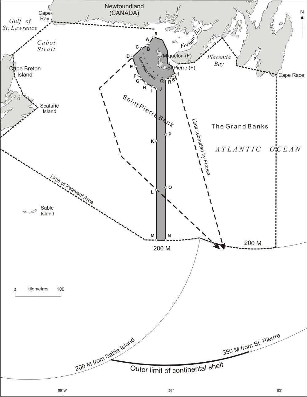
the other (the "baguette"), by producing a boundary which is reproduced
in the sketch map below (and if ever the adage that a picture is worth
a thousand words has application, it is here). The Court had a number
of ingenious explanations as to why it was taking this course. It recognized
that the French islands were a département of France, but also
that they were a long way from the mainland of France itself. Their
economic situation was more precarious than that of, say, the Channel
Islands. But it quite clearly held that it could not be otherwise than
swayed by the fact that St. Pierre Miquelon are small areas of land,
heavily dominated by the Canadian land masses represented by Newfoundland
to the north and Nova Scotia to the southwest, supporting a relatively
small population. International law and practice had developed somewhat
since the 1977 Arbitration, and it was clearly impossible to treat these
possessions as if they were part of, or lying just offshore, the mainland
of France. Consequently, St. Pierre and Miquelon were enclaved, just
as the Channel Islands had been before them, wholly within another States
EEZ/continental shelf. The critical difference was that the Court of
Arbitration granted to France a 200 nautical mile long and 10.5 nautical
mile wide strip of maritime jurisdiction. As noted, if this remarkable
spatial distribution of maritime space was intended to provide St. Pierre
and Miquelon with a corridor to the high seas it failed to do so quite
spectacularly. The whole of St. Pierre and Miquelon's bizarrely-shaped
maritime jurisdiction, which has been likened to a keyhole, a mushroom
cloud, or, with regard to the long strip of maritime jurisdiction, a
baguette, is enclosed within the Canadian EEZ. After the decision
was handed down, some of us who could hardly be classified as experts
in the practice of ocean resource exploration and production of any
kind wondered precisely how those concerned were going to live with
it. For the oil industry, the difficulties were relatively few. The
decision appeared to indicate the areas in which France could grant
licenses for petroleum activities, and those appertaining to Canada.
If a field was found to cross the boundary in such a way that it could
be exported, international law and practice had evolved the means for
ensuring that the correlative rights of all the interest holders, both
national and private, could be preserved, while at the same time ensuring
that the deposit would be dealt with in the most economically and technically
feasible manner. The decision posed a challenge, but the means were
at hand to meet it. But the situation was
very different as regards the fishing industry and the management and
conservation of living resources. This is a reference not so much to
the "baguette" itself, as the fact that marine areas lying outside
it within 200 nautical miles were presumptively closed to fishers from
the islands. The point was that exercising their rights within the baguette
would risk trespassing on Canada's 200 nautical miles exclusive economic
zone (as it now is), particularly given the Northwest Atlantic's heavy
weather. It would call for extra care and attention in being sure of
a vessel's position vis-à-vis the jurisdictional limits at virtually
all times. And, it perhaps goes without saying, there were those of
us that suspected the members of the court of arbitration had paid no
attention to these practical matters whatsoever in considering their
decision. Nor, one suspects, would the lawyers on either side have been
overly concerned. Their job was to fight a court case, and this had
been done. So far as they were concerned, the file was closed. If others
were now obliged to pick up the pieces and deal with the new reality,
that was their affair. Subsequent to the Court's decision, Canada and France
have concluded a fisheries accord and an announced (though not public)
hydrocarbons accord in order to address these practical marine resource management issues. One slice or two?
A Discontinuous outer continental shelf The first point to
make is that with its submission of preliminary information and, in
due course, its full submission for this area, France is not seeking
to reopen the boundary case - at least, not overtly. Both countries
agreed to abide by the decision of the arbitration in advance. It is,
of course, open to the two countries to set the decision aside and either
use it as a basis for negotiation, or ignore it all together, but they
did not elect to do this. Ergo, the decision stands. This is more than
a presumption. The prior agreement to accept the ruling was specifically
intended to introduce a degree of certainty into the proceedings. It
would scarcely be an incentive to engage in costly litigation had there
been the slightest thought that one side or the other might not agree
to abide by the result they didn't like. The current French position,
insofar as we have it, is very different. It is now accepted that all
coastal states have more or less absolute rights to exploit the living
and non-living resources of the sea, seabed and subsoil of their territorial
waters. Beyond the 12-mile
limit, the rights are somewhat less, but sufficient for complete coastal
state control over living and non-living resource activities. The issue
of 12 nautical miles from precisely what point of departure is often
overlooked, but it should not be here: because Canada uses Sable Island,
a sandbar to the east of the province of Nova Scotia, as a base point
for measurement and its 200 nautical mile limit encircles the seaward
extent of the baguette. This has no implications for issues such as
freedom of navigation, but most certainly does for living resource exploration
and management. For one thing, it means that the baguette is not a ten and
a half nautical mile wide "conduit" or passageway to the high seas but an
oddly-shaped French maritime enclave wholly surrounded by Canada's EEZ. An
incroyable claim? To understand the French
position, it is necessary to recall the rules of the Law of the Sea
Convention pertaining to countries that have a "natural" continental
shelf or continental margin extending beyond 200 nautical miles. It
is apparent from the wording of the Convention that the state presumed
to be in a position to make a claim to jurisdiction beyond 200 nautical
miles would be the same country that exercises jurisdiction on the landward
side of that limit. In other words, beginning on shore, and proceeding
through internal waters (if any), the territorial sea and the continental
shelf to the 200 nautical mile limit, and then possibly beyond, was
to be an exercise of jurisdiction by one sovereign entity only. This
interpretation of the Convention is borne out by the fact that no country
in any other part of the world is considering laying a claim similar
to that made by France. It will be difficult to see support in law or
logic for such a move. This is not to say it is illogical to seek jurisdiction
over any resources that might be available if there is a jurisdictional
uncertainty, but it appears that no such uncertainly exists here. The task of the Commission
is to match the evidence presented by the claimant that the state concerned
has met the requirements of Article 76 of the Convention, and that the
continental shelf or margin does indeed extend beyond that limit. The
task of the Commission is therefore one of scientific evaluation, and
nothing more. Under no circumstances will it, or indeed may it, adjudicate
between rival claims to jurisdiction. Indeed, the most likely scenario,
if France was to submit a formal claim to "outer" continental shelf
jurisdiction along the lines discussed here, is that Canada would deposit
an instantaneous and unambiguous objection to the Commission being seized
of the matter on the grounds that the area in question falls outside
the jurisdiction of France. Equally, in due course Canada will in all
probability itself make a submission seaward of its 200 nautical mile
limit. This, in turn, will, in all likelihood, prompt an immediate protest
from France. Consistent with its mandate the Commission is highly likely
to refuse to consider that part of either State's submission which
is subject to overlapping claims to jurisdiction. It does not take too
much imagination to imagine how other countries could use an essentially
spurious submission as a weapon against a neighbour. Of Bread...and Oil? While we are not aware
of any official pronouncements on this matter, one solution that has
been put forward by a resident of the islands (in the course of an interview
with CBC radio) was some form of sharing arrangement. It is not hard
to distinguish the underlying motives in this context. It should be
recalled that the islanders are interested in promoting mineral development
in order to alleviate their somewhat desperate economic plight, and
one can only sympathize with the situation in which they find themselves.
A community whose raison d'être was fishing is being starved
of fish: what, then, will sustain it? The idea that resources
which are potentially in dispute should be shared is not, of course,
new. There are many examples of zones of cooperation where countries
have agreed to joint development of an area with respect to petroleum
resources, or fisheries, or environmental management, or some combination
of these and other activities. Zones of cooperation are a potential
solution to a deadlocked jurisdictional puzzle, and indeed resort to
such arrangements is urged, albeit somewhat indirectly, by the Law of
the Sea Convention itself. The articles relating to the delimitation
of the exclusive economic zone on continental shelves calls for the
states concerned to enter into "provisional measures of a practical
nature" pending the resolution of their dispute. The many zones of
cooperation that have been established by states are both provisional,
in that they are not permanent arrangements, and (for the most part
anyway) practical in nature. But a zone of cooperation
can also be a weapon. Once the idea is accepted that countries might
be inclined to consider the joint development of an area merely because
it is subject to claim by a neighbouring state suggests that it is in
the advantage of all concerned to maximize their clams as much as possible,
whether these positions are justified by rules of international law
or not. A claim by France to exercise jurisdiction beyond the 200 nautical
mile limit offshore of the "baguette" and, more to the point, beyond
the 200 nautical mile limit of Canada, would be unique in international
practice to date. There are examples of zones of cooperation established
where the application of rules of international law has led to the development
of incompatible, but - at least to some extent - justifiable, jurisdictional
claims. Some of the blame for this must be laid at the door of the International
Court of Justice, as it developed notions on factors to be taken into
account when effecting a delimitation in one case, only to ignore them
(but seldom absolutely reject them) in the next. Perhaps the best illustration
of this is one of the early zones of cooperation, the offshore petroleum
joint development arrangement agreed to by Japan and South Korea in
1976. Korea's claim to the south of the peninsula includes a sizable
area which is undoubtedly closer to Japan than to it. Viewed on a simple
sketch map, the claim appears to be grossly exaggerated. But when the
geomorphology of the seabed is considered, it is seen that South Korea's
claim includes what certainly appears to be the natural prolongation
of its land mass. Japan, on the other hand, maintained that the median
line - equidistant from the coasts of the two states, ignoring the
configuration of the seabed - was the applicable principle. Since
neither side would give way, joint development and equal sharing of
resources was agreed on. The joint development zone is comprised by
the Japanese-claimed median line and the natural prolongation of the
Korean shelf. Natural prolongation has fallen out of favour, on the
whole, but its existence in the vocabulary of international maritime
boundary limitation law was of sufficient duration for it to have wreaked
a certain amount of damage, as various countries can readily attest. Prospects: Let them
eat...'Baguette?' One thing is crystal
clear: the Commission will not resolve this particular jurisdictional
headache. As the Commission is a scientific rather than legal body,
it lacks the mandate to consider areas subject to a sovereignty dispute
or subject to overlapping maritime claims. Furthermore, the Commission's
recommendations are specifically without prejudice to the delimitation
of maritime boundaries. Ultimately, therefore, it remains up to Canada
and France to address and resolve any overlapping maritime claims and
disputes - the Commission simply will not consider the matter. The government of Canada
is of course free to enter into joint development or any other form
of cooperative arrangement if it wishes. But it is surely undesirable
from the point of view of international law and policy that countries
consider themselves to be over a barrel, as it were, in that they are
faced with two unpalatable options: agree to cooperate, or face a very
long stand-off resulting from a neighbouring state laying a questionable
claim to extended continental shelf jurisdiction, as described above.
Arguably, this scenario was not foreseen by the Law of the Sea Convention.
However, it is suggested that the intent of the relevant provisions
of the agreement are clear: jurisdiction was seen as a continuum from
land territory to the furthest seaward region of maritime jurisdiction
determined according to the rules of international law. The leap-frogging
outer continental shelf assertion envisaged by France on behalf of St.
Pierre Miquelon is at variance with what appears to be an unambiguously
established principle. As we said, it is not
difficult to appreciate the sentiments of the islanders with respect
to the prospect of a share in offshore resource development. But international
laws in practice are precisely that - international. It does not seem
helpful to establish an international precedent which would allow one
country to be in a position to exact jurisdictional concessions from
a neighbour, nor indeed to subvert the clearly enunciated rules and
principles relating to means whereby maritime jurisdiction beyond the
limits of the territorial sea is generated. Natural resource jurisdictional
matters are sufficiently fraught topics in the field of international
relations: nothing is to be gained by making the situation worse. Notes: |